GYC and partners release final Greater Yellowstone Climate Assessment to public
The Greater Yellowstone Ecosystem is valued for its diverse forests, fish, wildlife, and water. There is no other place like it in the world, so when scientists approached GYC to partner on a new report to address the impacts of climate change, we joined the team without hesitation.
Released earlier today, the Greater Yellowstone Climate Assessment Report is the first report of its kind to take an ecosystem-wide look at climate impacts. It focuses on six watersheds in Greater Yellowstone, and represents three years of collaborative efforts between researchers, agencies, institutions, and non-profits. Scientists with the U.S. Geological Survey, Montana State University, and the University of Wyoming studied climate change in Greater Yellowstone from 1950-2018. To assist with their analysis, GYC interviewed people who live and work throughout the region to gain insight on their concerns, the impacts they are seeing on the ground, and what policies they feel would be valuable in helping mitigate climate impacts.

Lower Green River Lake in the Bridger Wilderness, Wyoming. (Photo Bridger Teton National Forest)
The report summarizes how climate change could progress by 2100 based on various greenhouse gas emission scenarios and concluded that since 1950, temperature significantly increased and snowfall decreased because of climate change. And the trends are likely to continue.
This means big changes ahead. By the end of the century, the region could see:
Annual precipitation increase by 9-15%, but the combination of elevated temperatures and higher evaporation rates will likely make future conditions drier in summer;
Reduced soil moisture in the summer months, which will be an additional stress on plant communities that could make drought and wildfires more common; and
40-60 more days per year exceeding 90 degrees Fahrenheit in Bozeman, Montana, and in Jackson, Pinedale, and Cody, Wyoming, if there is little to no mitigation of future emissions.
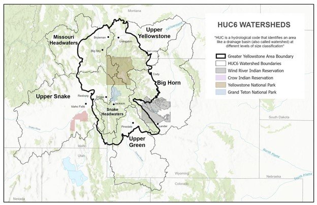
Map of the Greater Yellowstone Area (GYA) showing the six Hydrologic Unit Code 6 (HUC6) watersheds studied under the Assessment, and including mountain ranges, lakes and major river systems, jurisdictions, and selected towns. The portions of the watersheds within the GYA boundary are studied in this report.
GYC plans to tackle the complex challenges facing the region by working with people to address changes in temperature, snowpack, disease, wildfires, and other issues impacted by climate. This report will help guide our work well into the future.

—Charles Drimal, Waters Conservation Coordinator